Geography of Croatia
The geography of Croatia is defined by its location at the crossroads of Central Europe and Southeast Europe, and the wider region of Southern Europe. Croatia's territory covers 56,594 km2 (21,851 sq mi), making it the 127th largest country in the world. Bordered by Slovenia in the northwest, Hungary in the northeast, Bosnia and Herzegovina and Serbia in the east, Montenegro in the southeast and the Adriatic Sea in the south, it lies mostly between latitudes 42° and 47° N and longitudes 13° and 20° E. Croatia's territorial waters encompass 18,981 square kilometres (7,329 sq mi) in a 12 nautical miles wide zone, and its internal waters located within the baseline cover an additional 12,498 square kilometres (4,826 sq mi).
Read article


.jpg)


.jpg)


Top Questions
AI generatedMore questions
Nearby Places
Komora
Village in Continental Croatia, Croatia

Gvozdansko
Village in Continental Croatia, Croatia
Trgovi
Village in Continental Croatia, Croatia
Donja Stupnica
Village in Continental Croatia, Croatia
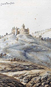
Siege of Gvozdansko
Part of the Hundred Years' Croatian-Ottoman War

Zrinska gora
Rujevac, Croatia
Village in Continental Croatia, Croatia
Kosna, Croatia
Settlement in Sisak-Moslavina County, Croatia